
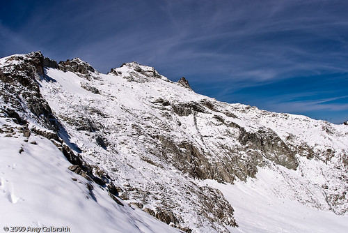
A view of east peak Mount Daniel from the southeast ridge.
David noticed an article about some people summitting a mountain in the Cascades called Mt. Daniel. Read it here in the PDF if you're interested: Scrambling Daniel. Seeing as how they didn't use any climbing equipment and only trekking poles, this sounded like a challenging, but doable task for the two of us. It also sounded like a great way to say goodbye to summer and look forward to winter...Well, here's how the story goes.
The route to Mt. Daniel begins from a little area called Peggy's Pond. You might remember me talking about Peggy's in a previous post titled "Mosquitoes Suck." Luckily, the mosquitoes have pretty much retreated and died off for the summer so this time we didn't have the problem. The day we left was pretty soggy. The trail was muddy, both of us were coming down with colds, and it was freezing. The rain was just a drizzle for most of the hike to Peggy's so it was definitely tolerable. When we reached Peggy's we set up camp and made dinner. The night proved to be pretty chilly. I didn't take my hat off the whole time and felt like I couldn't zip my sleeping bag up enough to keep warm. It had to have dropped well into the 20s that night.
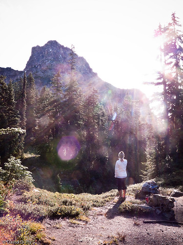
The next morning we woke up to a layer of frost on the ground, and a beautiful clear and sunny sky. We were very thankful for warm oatmeal and hot coffee for breakfast. We bundled up, grabbed our trekking poles, and headed out to climb Mt. Daniel.
I'm loving the morning sun here.
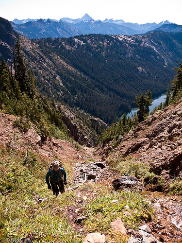
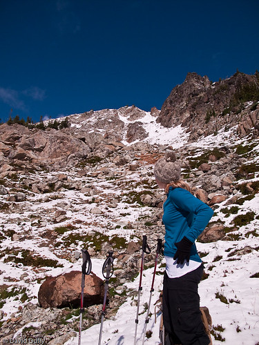
Standing at nearly 8,000 feet (puny in comparison to what I've seen in the Tetons) is Mt. Daniel. It's covered in snow most of the time but the route to the top is pretty passable. There were a couple of routes described in the web story. One was a route up to a snow field. We tried to shoot for that one but ended up taking a very off-the-beaten-path way up the southeast ridge. We began by hiking what we thought was the climbers trail up the southeast ridge. This "trail" proved to be quite challenging. There were a few cairns along the way, but nothing that looked like an actual trail. We climbed steep scree covered slopes, traversed a bit, and then we realized we were a bit trapped. It was either turn back (there was no way to traverse further), or climb a steep stream bed. We were stuck climbing up a stream bed. This was an interesting experience, and definitely a test of my courage. I felt like turning back multiple times.
Not sure how I made this climb. Taking a breather after the stream bed.
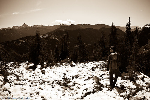
David, Mt. Stuart behind.
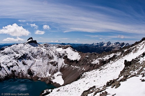
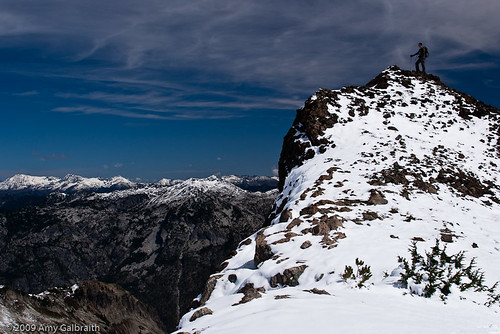
When we reached the top of the stream bed, we were faced with climbing a snow covered slope to the top of the southeast ridge. This was challenging, but not as bad as the stream bed. Most parts of the snow were easy to get grip, and the worst part was at the top but it was very doable. When we got to the top, we could very clearly see the east peak of Mt. Daniel. It looked like it would take forever to get there, and we were trudging around in what seemed like a foot of fresh snow. The views from here were beautiful. From Mt. Stuart, Circle Lake, and Bear's Breast, all the way to Mt. Rainier and Mt. Adams was clear. I felt as if I was on top of the world. Unfortunately, I did not feel confident with climbing the rest of the way to the summit. It looked dangerous. There were cornices that had formed, and so much snow to cross! We decided to turn back :( This is the one time when early season snow is at my disadvantage.

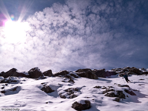
Blazing the trail. First tracks!
The best view ever!
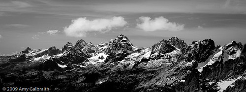
Bear's Breast...mini Tetons?? :)
David's on top of the world.
On the way down, we followed the southeast ridge in a different direction. Looking at the topo map, it seemed like we could find a shallower slope to descend on and not have to climb down the creek bed...whew! The way down was marked with lots of cairns, and the snow made it really easy to keep a good footing. I felt much safer this time.
I'm trudging through snow at the end of summer...weird.
When we reached the edge of the ridge, we saw a beautiful little lake at the base of Cathedral Rock, appearing to be Peggy's Pond. This is where we got confused. This lake was beautiful and blue. A little mountain gem. According to the map, it was Peggy's. David was sure that we weren't camped by that lake. I remained hopeful. If it turned out to not be where we were camped, it meant that we would have taken the wrong route to climb Daniel, starting from a lake that wasn't even Peggy's! Sure enough, as we descended further we noticed a crappy little swamp...with our tent next to it...just next to the real Peggy's Pond. We started from the wrong place! No wonder the ascent was so difficult!!
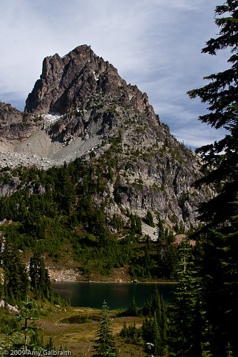
The real Peggy's Pond.
We walked up to Peggy's Pond, in awe of how beautiful it actually was. We continued on the trail to the crappy lake that we were near, naming it Peggy's Piss. How disappointed we were. Our whole route to the top of Daniel would have been much easier had we actually started from the right spot. What an annoying mistake.
I guess we learned a few things on this trip. Maps really do help. We weren't far from the real Peggy's but it definitely made our trip to the top of Daniel very challenging. We have been watching the weather this week and it seems like a lot of the snow will be melting on Mt. Daniel so we might try again next week. Until then, enjoy the gorgeous pictures we got from our trip, and hopefully next time I'll be raving about how we made it to the summit.
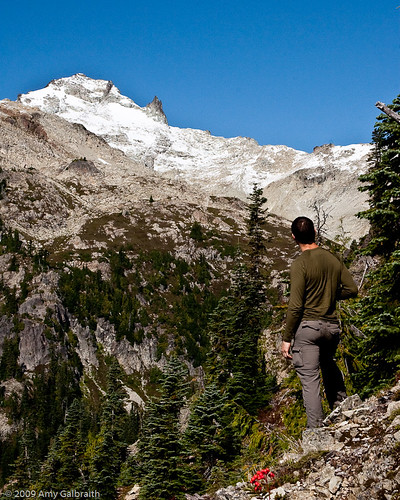
David gazing up at where we should have been.
No comments:
Post a Comment